Bluie West One
| Type | 203 Air Base | |
| Historical Name of Location | Narsarsuaq, South Greenland, Greenland | |
| Coordinates | 61.160636000, -45.425878000 |
Contributor: C. Peter Chen
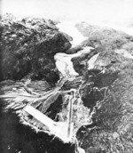
ww2dbaseThe US Army constructed the airfield of Bluie West One in southern Greenland beginning in Jun 1941. The site was surrounded by high mountains, thus most flights traveled over the Tunulliarfik Fjord. The runway was constructed of steel mat. The first aircraft landed in Jan 1942, and for the remainder of the war it served as a refueling point for the Canada-Greenland-Iceland-Scotland route. At its peak during the war, about 4,000 US military personnel were stationed at this airfield. About 10,000 landings were conducted at Bluie West One between 1942 and 1945. After the end of WW2, it remained active under the new name of Narsarsuaq (alternate spelling: Narsarssuak) Air Base. As jets became the norm, the runway was lengthened and was paved with concrete. In 1958, the base was closed and control of the facilities was given to the government of Greenland, which then operated it as a civilian facilities. It remains in that capacity at the time of this writing in 2019.
ww2dbaseSource: Wikipedia
Last Major Update: Sep 2019
Bluie West One Interactive Map
Photographs
 |  |  |  |
Please consider supporting us on Patreon. Even $1 per month will go a long way! Thank you. Please help us spread the word: Stay updated with WW2DB: |
| WW2-Era Place Name | Narsarsuaq, South Greenland, Greenland |
| Lat/Long | 61.1606, -45.4259 |
- » 1,167 biographies
- » 337 events
- » 44,601 timeline entries
- » 1,243 ships
- » 350 aircraft models
- » 207 vehicle models
- » 376 weapon models
- » 123 historical documents
- » 261 facilities
- » 470 book reviews
- » 28,520 photos
- » 367 maps
Fleet Admiral Chester W. Nimitz, 16 Mar 1945
Please consider supporting us on Patreon. Even $1 a month will go a long way. Thank you!
Or, please support us by purchasing some WW2DB merchandise at TeeSpring, Thank you!